

At Claudelands Events Centre, our client required accurate underground utility information to support upcoming works at the site. With the area being both heavily used and historically important, minimising disruption while gathering reliable data was essential.
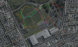
Our team was engaged to carry out a comprehensive utility investigation using a combination of Electromagnetic Locating (EML) and advanced Ground Penetrating Radar (GPR) in both 2D and 3D formats. This blended approach ensured maximum coverage and accuracy, allowing us to locate utilities across a wide range of depths and ground conditions.
To complement the locating work, all utilities were surveyed with high-precision GPS equipment. This step not only provided spatial accuracy but also ensured that the information could be seamlessly integrated into the client’s wider project planning. By combining detection and survey in one workflow, we were able to deliver a clear picture of the subsurface environment.
The final deliverables were issued in both DWG and PDF plan set formats. This dual output allowed for straightforward integration into CAD systems while also providing user-friendly plans for quick reference on site. The result was a set of clear, reliable, and professional outputs that the client could immediately apply to their project planning and construction processes.
Through this project, we demonstrated the value of combining multiple detection technologies with robust survey practices. Our client received accurate and actionable data, reducing risk and helping to ensure that future works at Claudelands Events Centre can proceed safely and efficiently. This project is a strong example of how we tailor our methods and outputs to meet both the technical and practical needs of our clients.
